

A useful Yunnan travel map separates the province into route families. The classic northwest corridor, the Tea Horse Road, southern Yunnan and the Meili Snow Mountain extension should not be treated as short stops on one crowded circuit.
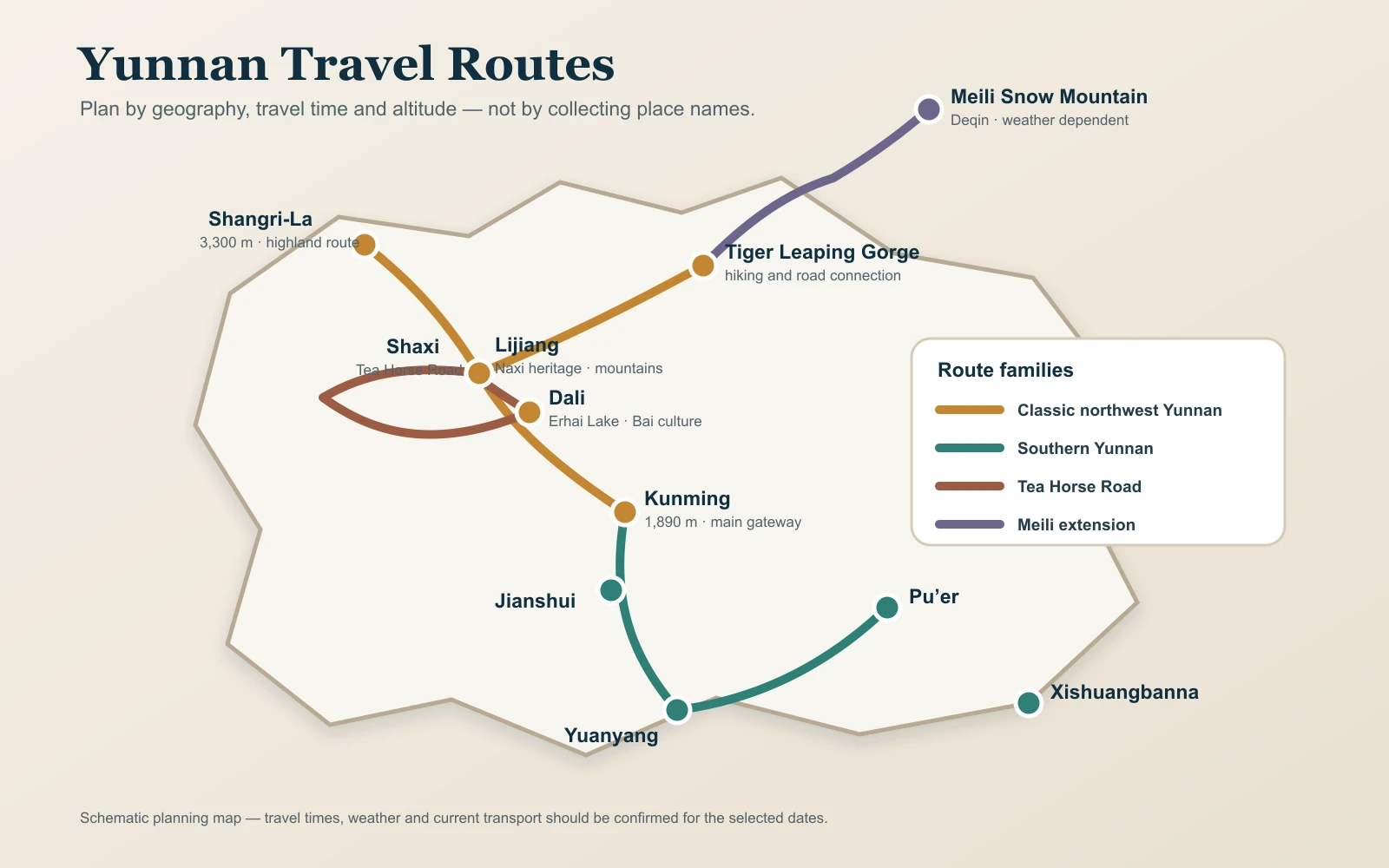
Main Yunnan Gateways
Kunming
Kunming is the province’s main aviation and rail gateway. It works as a first acclimatisation stop, a base for the Stone Forest or a connection toward Dali, southern Yunnan and other Chinese cities.
Lijiang
Lijiang has useful air and rail access for travellers beginning in northwest Yunnan. It connects naturally with Dali, Shaxi, Tiger Leaping Gorge and Shangri-La.
Xishuangbanna
Jinghong provides the main gateway for tropical southern Yunnan, with rail and air links. The rainforest, tea and village areas then require local road travel.
Indicative Travel Times
| Sector | Typical transport | Indicat |
Planning note |
|---|---|---|---|
| Kunming–Dali | High-speed train | About 2–3 hours | Add both station transfers and security time |
| Dali–Lijiang | Train or road | About 2 hours by train | Road works better when Shaxi or villages are included |
| Lijiang–Shangri-La | Train | About 1.5 hours | The elevation change still deserves a gentle arrival day |
| Lijiang–Tiger Leaping Gorge | Road | About 2–3 hours depending on trailhead | Trail and luggage arrange |
| Dali–Shaxi | Road | About 2.5–3.5 hours | Fits naturally between Dali and Lijiang |
| Kunming–Jianshui | Train | About 2 hours | Useful gateway for a southern road route |
| Jianshui–Yuanyang | Road | About 3–4 hours | Winding roads and viewpoint location affect timing |
| Kunming–Xishuan |
Train or flight | About 3.5–4.5 hours by train | Compare door-to-door time, not only the timetable |
| Shangri-La–Deqin | Road | About 4–6 hours | Mountain weather and road conditi |
These are planning estimates. Confirm the actual schedule, station and road access for the selected dates through the responsible operator.
Route 1: Classic Northwest Yunnan
Kunming → Dali → Lijiang → Shangri-La is the most efficient first route. It moves from a major gateway toward higher elevations, combines train and road options and supports a clear cultural progression. Use six to eight days for Kunming, Dali and Lijiang; allow eight to ten days when Shangri-La is included.
Route 2: Tea Horse Road
Dali → Shaxi → Lijiang replaces a direct train with a slower road chapter. Shaxi makes sense when the goal is historic trade routes, village context and quiet evenings. Two nights are better than a late arrival and early departure. This route can continue to Tiger Leaping Gorge or Shangri-La.
Route 3: Southern Yunnan
Kunming → Jianshui → Yuanyang → Pu’er → Xishuangbanna links courtyard towns, rice terraces, tea and tropical ecology. It is a substantial regional journey, not a side trip from Dali. Nine to thirteen days creates a more coherent sequence; shorter trips should choose Jianshui and Yuanyang or Pu’er and Xishuangbanna.
Route 4: Meili Snow Mountain
Shangri-La → Benzilan → Deqin/Feilaisi is a highland road extension. It needs weather flexibility, warm clothing, sensible altitude planning and no confirm of mountain visibility. Travellers continuing to a trek need separate fitness, equipment and support decisions.
Where Flights Help
Flights can save time when Yunnan is combined with Beijing, Shanghai, Xi’an or Chengdu, and when southern Yunnan is added to a northwest route. However, an airport day still includes checkout, transfer, security, baggage and arrival. A short flight should not automatically replace a direct train.
Where a Private Vehicle Adds Value
- Dali villages and Erhai areas outside the easiest public transport
- Shaxi and Shibaoshan between Dali and Lijiang
- Tiger Leaping Gorge trailheads and luggage transfer
- Yuanyang viewpoints and villages
- Tea, coffee and rainforest areas around Pu’er and Xishuangbanna
- Mountain roads from Shangri-La toward Deqin and Meili
Plan for Altitude as Well as Distance
| Base | Approxi |
Route implica |
|---|---|---|
| Kunming | About 1,900 m | Useful first base and transport gateway |
| Dali | About 2,000 m | Moderate elevation with room for a slower day |
| Lijiang | About 2,400 m | Mountain activit |
| Shangri-La | Above 3,000 m | Protect rest time and seek medical advice for relevant concerns |
| Deqin/Feilaisi | High-altitude mountain region | Road, cold and individ |
How to Use This Map
- Choose one route family for a trip under ten days.
- Identify the international or domestic gateway.
- Count hotel-to-hotel travel, not only train or flight time.
- Place the highest or most weather-sensitive experience after acclimatisation.
- Remove the stop that creates the most backtracking.
Then compare the Yunnan itinerary options and private Yunnan tours.
Frequently Asked Questions
Can I see all of Yunnan in ten days?
No. Ten days supports a strong northwest route or a focused southern route, not the full province.
Is there a train from Lijiang to Shangri-La?
Yes, rail service connects them. Confirm the current timetable and allow for station transfers.
Can I take a train to Shaxi?
No direct railway serves Shaxi. Road transport is required from the Dali or Lijiang side.
Should I fly or take the train from Kunming to Xishuangbanna?
Compare the full door-to-door journey, fare and preferred departure. Rail can be convenient; a flight may fit an onward connection.
Does the map show exact distances?
No. The map is schematic: it helps compare route relationships, rail corridors and the scale of regional transfers. Check the current rail or road timetable and the exact hotel locations before using it to set a same-day connection.
Which route is best for a first visit?
Kunming, Dali and Lijiang are the simplest core. Add Shangri-La when time and altitude suitability allow.
Turn the Map Into a Real Route
Send your dates, gateway city, pace and priorities through Plan My Trip. VeroTrip can replace the schematic outline with current transport and a dated service plan.
Continue Planning Your Yunnan Trip
Use these Yunnan resources to compare route length, season, transport, budget and private travel options before fixing the daily sequence.